The Autumn Leaves …


Before going on a trip, I took a picture of the backyard. We knew it would appear differently after being away from home for a few weeks.


With over 50 maple trees in the backyard, and a few cottonwoods, each fall harkens a duty not looked upon as joyous.


Using a combination of raking ...


... and blowing with an industrial leaf blower ...


... we finally completed the job! (We had three piles this size!)

Key Lime Pie


In 1980, we visited Key West, Florida and had our first taste of Key Lime Pie. We enjoyed it, and Carol obtained a recipe so she could bake it at home. The limes grow wild in the Florida keys.


It was scrumptious and continued to be a treat for special occasions. Carol would also bake it for a neighbor lady and her husband.


The neighbor lady also savored the pie and was enthralled by its unique taste. It was not the only reason, but the pie was a major incentive for her to give us her automobile, which had less than 17,000 miles on the odometer! (Moral: Be kind to your neighbors!)

Eugene is Number 2!


The national magazine, "Bicycling," rates Eugene the second best cycling city for its size. Boulder, CO is first for a similar population, and Portland, OR is rated best—of all the cities—in the nation! Boulder earned first place because of very strong work-day, commuter bike-travel. Eugene has more emphasis on recreational use.


Eugene has 30 miles of off-street paths, such as this bridge, and 89 miles of on-street bike lanes. As early as 2009, the sixth bike-bridge is planned; autos have three bridges. In 2005, the 130-mile Willamette Valley Scenic Bikeway was established. (Oregon has the world's best mountain biking trail, on which I'll post images and a narrative later.)

Scenic Outdoors

Today's post will feature the beauty of Oregon's forests and mountains. This image is the trail to Lookout Creek in an old growth forest that is protected from logging. The forest canopy is so thick that it diminishes the light for sharp photography. Still, the verdant mosses and lichen create a luminescence on the forest floor.


Lookout Creek splashes its way through an old growth forest. This bridge is part of a six-mile looping trail that is rather primitive. The next time I crossed the creek, farther along the trail, I had to scoot across the chasm on a log on my bottom! (Note the huge log on which I'm standing that is used for the bridge!)


In the background are the "Three Sisters," all above 10,000 feet in elevation. The ridge I'm on is part of the "Old Cascades," which are 30 million years old. They were as high as the Sisters, but the erosion of time has worn them into foothills. Millions of years ago, they were where the Sisters are now; notice how far the tectonic plate has moved west!


In the background is Mt. Washington, 7,794 feet in elevation. Accompanied by our younger son, I climbed to the part where the peak becomes dramatically steeper. Without ropes and pitons with us for climbing protection, I decided not to ascend the remaining height. The more vertical section has claimed the lives of hapless climbers.


After a day of trekking, on the way home I decided to climb Castle Rock, 3,308 feet in elevation. A fire lookout, long abandoned, used to occupy this promontory. The peak is southwest of McKenzie Bridge, Oregon and looks down on a portion of the Tokatee golf course, rated one of the most beautiful in the state.

X-C Ski Adjunct

Two day ago, I posted my ski trek and was about to delete the digital "outtakes." I thought, "There may be some interest in the images that were not included." So, here is a bit of trivia: We have driven this 1975 Honda since 1977. For winter mountain travel, I outfitted it with four, studded snow-tires and it climbs the icy hills like a bobcat. The ski rack, bought in 1960, is used most every year.

Since I decided to ski south, upon leaving the Gold Lake Sno-Park, I entered a logging road that is closed for the winter. It is the main access to a plethora of trails and a couple of shelters along the spine of the Cascade Mountains.


Shortly after skiing along the logging road, I passed a "snow-stake," which measures the depth of the snow. Hydrologists, the people who predict water levels, are interested in how much snow has fallen. They use this information, especially the "Snow-Water Equivalent," to predict how much water is going into the water table and eventually into the lakes and rivers.


If you do not ski cross-country, you might ask,"How does one find their way through a forest of new-fallen snow that has obliterated all tracks AND the trail?" Every few yards is a trail marker in a tree; it is attached high off the ground to prevent being buried during a deep snowfall.


The Bechtel Shelter is a welcomed haven from unexpected storms for snow travelers, whether they be on skis or snowshoes.


Thanks to the hard work of volunteers, an ample supply of firewood is stacked during the summer. An axe is provided to split kindling to aid in starting a fire in the wood stove for heating and cooking. The rising, warm air provides toasty comfort while sleeping in the "upstairs" loft!

Cross Country Skiing


At the Gold Lake Sno-Park, one mile west of Willamette Pass, is a parking area to begin cross country skiing north or south. This is near the Pacific Crest Trail system in which one could ski, theoretically, from Canada to Mexico, IF there was enough snow!


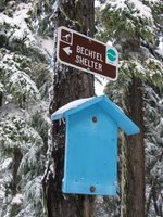
Today, I'll be skiing to Bechtel Shelter. For skiers who are new to the area, there are signs at each junction of trails directing the uninitiated to their goal. There are many trails and several shelters along the crest of the Cascade Mountains. The blue board will soon have a "You are here!" map of the area mounted for the directionally dyslexic.


Winter, wearing a mantle of white, brings sublime beauty to the forests. As I ascend the mountain, I look back at my ski track. One of trails to the shelter follows this route, which is a logging road in the summer. On weekends, volunteer ski patrolmen ski these trails to aid anyone who might be in distress.


Once in awhile, I'm able to glimpse an alpine ski area through the trees. It is "The Pass," situated at 5,120 feet at the summit of Willamette Pass. We were on the ski patrol there in the early 1970s. At that time, the area had one poma lift and one rope tow on one slope. Now there is one high-speed "six-pack," three triple and one double chairlifts that range from the front to the backside of the peak. These service 29 downhill trails.


Bechtel Shelter is one of several shelters in this general area of Willamette Pass. Thanks to volunteers, it is stacked with fire wood before the snow flies and has a wood stove for heat. The sleeping area is "upstairs" where the warm air from the stove accumulates. All shelters can not be reserved and are on a first come, first served basis. However, back country skiers are quick to share the shelter with other adventurers.


On every ski outing, I always bring a thermos of hot chocolate. The thought of its warmth, sweetness and thirst-quenching flavor is a powerful incentive to kick and glide my way back to the car. The skis are hurriedly placed on the cartop ski rack, and I plunge into my guiltless chocolate addiction ... and wash down a granola bar!

Ankeny Bottom Wildlife Refuge

A few miles south of our capitol, Salem, are the bird-rich wetlands of the Ankeny Bottom. Due to an elevated boardwalks, we were able to walk through marshy forests to view the habitants and keep our feet dry. This area was first established in the 1960s to provide a home for the dusky Canada goose. They spend their summers in Alaska and winter in Oregon.


To allow visitors to see waterfowl activity, without being seen, there are bird-watching blinds built along the walkways. While there, we heard a cacaphony of sound, and turning around saw the sky darkened by geese. This refuge is home to geese, herons, ducks, sparrows, redwing blackbirds and an occasional bald eagle.


These bird-watching blinds have "peep" holes that can be covered and uncovered to watch the avian comings and goings. In the soft rays of sunset, Carol is watching a flock of ducks feeding in the distance.

Eugene is having its usual mild winter. The morning of December 18, 2005, we noticed the Buick in the driveway had icicles on the rear spoiler that melted by noon. Today is January 23, 2006, and we haven't seen any ice depositions though the temperature has dropped a few nights.


Due to more rainfall than usual, our backyard became a playground for the "Oregon Ducks!" They swam into our yard from the National Wetlands that is next to our property. Because they are wild, I used a telephoto lens to film through our garage window. Occasionally, wood ducks would appear in their colorful plumage.

Old Road

When this reservoir was drained in 2005, an artifact emerged. The old, forgotten road that connected Eugene with Florence, Oregon was visible again. These pilings supported a bridge that rotted long ago over the creek.This relic was used by Indians, settlers, and wagons in a two-day trip to the coast. In those days, it had to follow the easiest path. In doing so, it bypassed Mapleton, Oregon, a route unthinkable today.

Fern Ridge Contrasts


Fern Ridge, a flood control reservoir, is not at full capacity in this scene. The Corps of Engineers needs extra capacity to catch any sudden snowmelt that could overwhelm the reservoir. Compare this view, taken January 2006, with the following image photographed September 2005.


I'm in the middle of the "lake"! It is extremely unusual to see the reservoir without water. The water was drained so repairs could be made to the dam. It is possible that this will NOT be experienced again in a lifetime!

A Dam Trip …


The local news had reported flooding in the low lying areas of the state, so we drove around looking for instances of high water. One of the reservoirs, Fern Ridge, was letting water out of its dam to provide room for snowmelt in an emergency.


The water from Fern Ridge dam was released in the Long Tom River. Residents downstream complained that it was overflowing into their pastures. The unenviable job of the Corps of Engineers is a tightrope walk in flood control.

Water, water everywhere!

We have been experiencing a winter that has had more rain than usual. Because of it, we had water in the lower portion of our back yard. (It posed no flood danger to our home which sits much higher.) The National Wetlands adjoins our back yard—where you see the vegetation in the background—but rarely has the water been this high. I'm raking detritus from the surface of the water into piles to facilitate cleanup when the water recedes. The ducks have been enjoying this watery windfall!