This photo was taken in 1979, as we are ready to depart for Alaska. It is a photo of Carol, Roy and mother, Elia, in front of the 1972 Cabana motor home. The motor home has recorded over 200,000 miles while on our way to Yakima (see earlier blog). Trivia: Roy's mother is eight years younger in the photo than Roy is NOW!
After 34 years, the step for entering and exiting the motor home rusted "a little!" It was MORE than ready for replacement. Instead of using a similar step, which is still manufactured, I decided to construct a longer lasting step.
The metal step rusted because I covered it decades ago with a carpeted board to increase the step area for Carol. This combination of carpet and wood retained moisture through the decades to accelerate rusting.
I cut the new step out of heavier gauge metal. This step will last many times longer than the original step.
To slow the process of rusting, I applied two coats of high-temperature paint.
After applying contact cement to the new step, I glued a carpet to it's surface and placed six clamps to insure bonding. (Trivia: Due to laying down a new carpet in the school, this carpet was removed from the classroom in which I taught for ten years from 1969 - 1979. It had been trod upon by thousands of students and this teacher for many miles!)
Though the factory installed step was riveted on, I used bolts this time so the step could be easily removed and repaired as needed. Since the steel plate is heavier than the original metal, it should last 40 years!
Crilly Nature Trail
Crilly Nature Trail is on the north side of Eugene, Oregon in Armitage Park near the McKenzie River. It is a deciduous forest habitat that grows along the banks of the river. The trail has low spots that would fill with water in the winter before dams were built to control flood water. The steps provide easier ascents and descents in the gullys.
Carol is pointing to a large cavity in a big leaf maple that provides a habitat for small birds and animals.
A rotten "nurse" stump acts as a seedbed (or nursery) for young forest plants. As the stump decays, it provides nutrients and rich soil that is recycled back into the forest.
Growing out of the big leaf maple is licorice fern, that depends on the moisture in the heavy covering of moss on the tree. The rootstock was important to the early settlers as a sweetner, to flavor tobacco and to make medicinal tea.
The winds and storms of winter drop an occasional tree across the path. The trail maintenance crew will remove the tree later. In the meantime, Carol utilizes her scrambling skills!
We saw this leaf on the trail that lost all of its "body" except for the "veins" of its structure. I placed it over a brochure to reveal its transparency!
Trip to Yakima, Washington
We were planning to travel to Yakima but awakened to an unexpected surprise. This was the third snowfall in Eugene, Oregon on this date since 1937!
So, the motor home will remain idle until the next day. (All the snow melted before noon.)
Our reason for traveling to Yakima was to assist our two Canadian-born granddaughters (Sami and Kai) in becoming U.S. citizens. Their American father, our son, had lived in Canada too many years to simplify the process.
The Yakima Greenway is a large city park on the east side of town that features picnic areas, a soccer field, playground, jogging path, exercise stations, fishing ponds and a WW II relic.
Geese, among other avians, are residents of the park and enjoy the large ponds.
The jogging path parallels the Yakima River for a mile. There were many citizens who donated to the building of the Greenway, and every few yards is a plaque dedicated to a contributor.
Every 1/4th mile along the jogging path is a "mileage" marker. In Eugene, the marker is embedded in the bike path, but along the Greenway it is a concrete pylon.
There are 21 different exercise stations along the jogging path. This one is for strengthening the triceps. Place heels on the elevated table in the center, while supporting body weight between the tee-shaped bars. Lower the body between the bars, by bending the elbows, then straighten arms to elevate the torso.
An interesting artifact in the park is this boxcar from the "merci," French Gratitude train. This was presented to Washington State in 1949 from the citizens of France.
The gift was an expression of gratitude for food, fuel and clothing donated to the needy people in war ravaged France and Italy in WW II.
Bryn, Ada, Kai and Sami joined us for a Mexican dinner in the Cabana. The 23-foot motor home is rather cozy for a large family gathering.
Following bean burritos and tostados, Carol concentrates on her daily puzzles.
Bryn, Ada, Kai and Sami are waiting outside the Naturalization Center. Due to Homeland Security, we were not allowed to enter the building as a group, only one at a time, and I was not allowed to photograph the girls' swearing-in ceremony!
Driving home, we stopped near Memaloose Island in the Columbia River, a burial island for the Chinook Indians. Before Bonneville Dam, it encompassed four acres, now it's 1/2 acre. Graves were relocated before the water rose. One of Oregon's first senators stated he wanted to be buried there, in 1883, because "In Resurrection, I'll take my chances with the Indians!"
The Autumn Leaves …
Before going on a trip, I took a picture of the backyard. We knew it would appear differently after being away from home for a few weeks.
With over 50 maple trees in the backyard, and a few cottonwoods, each fall harkens a duty not looked upon as joyous.
Using a combination of raking ...
... and blowing with an industrial leaf blower ...
... we finally completed the job! (We had three piles this size!)
Key Lime Pie
In 1980, we visited Key West, Florida and had our first taste of Key Lime Pie. We enjoyed it, and Carol obtained a recipe so she could bake it at home. The limes grow wild in the Florida keys.
It was scrumptious and continued to be a treat for special occasions. Carol would also bake it for a neighbor lady and her husband.
The neighbor lady also savored the pie and was enthralled by its unique taste. It was not the only reason, but the pie was a major incentive for her to give us her automobile, which had less than 17,000 miles on the odometer! (Moral: Be kind to your neighbors!)
Eugene is Number 2!
The national magazine, "Bicycling," rates Eugene the second best cycling city for its size. Boulder, CO is first for a similar population, and Portland, OR is rated best—of all the cities—in the nation! Boulder earned first place because of very strong work-day, commuter bike-travel. Eugene has more emphasis on recreational use.
Eugene has 30 miles of off-street paths, such as this bridge, and 89 miles of on-street bike lanes. As early as 2009, the sixth bike-bridge is planned; autos have three bridges. In 2005, the 130-mile Willamette Valley Scenic Bikeway was established. (Oregon has the world's best mountain biking trail, on which I'll post images and a narrative later.)
Scenic Outdoors
Today's post will feature the beauty of Oregon's forests and mountains. This image is the trail to Lookout Creek in an old growth forest that is protected from logging. The forest canopy is so thick that it diminishes the light for sharp photography. Still, the verdant mosses and lichen create a luminescence on the forest floor.
Lookout Creek splashes its way through an old growth forest. This bridge is part of a six-mile looping trail that is rather primitive. The next time I crossed the creek, farther along the trail, I had to scoot across the chasm on a log on my bottom! (Note the huge log on which I'm standing that is used for the bridge!)
In the background are the "Three Sisters," all above 10,000 feet in elevation. The ridge I'm on is part of the "Old Cascades," which are 30 million years old. They were as high as the Sisters, but the erosion of time has worn them into foothills. Millions of years ago, they were where the Sisters are now; notice how far the tectonic plate has moved west!
In the background is Mt. Washington, 7,794 feet in elevation. Accompanied by our younger son, I climbed to the part where the peak becomes dramatically steeper. Without ropes and pitons with us for climbing protection, I decided not to ascend the remaining height. The more vertical section has claimed the lives of hapless climbers.
After a day of trekking, on the way home I decided to climb Castle Rock, 3,308 feet in elevation. A fire lookout, long abandoned, used to occupy this promontory. The peak is southwest of McKenzie Bridge, Oregon and looks down on a portion of the Tokatee golf course, rated one of the most beautiful in the state.
X-C Ski Adjunct
Two day ago, I posted my ski trek and was about to delete the digital "outtakes." I thought, "There may be some interest in the images that were not included." So, here is a bit of trivia: We have driven this 1975 Honda since 1977. For winter mountain travel, I outfitted it with four, studded snow-tires and it climbs the icy hills like a bobcat. The ski rack, bought in 1960, is used most every year.
Since I decided to ski south, upon leaving the Gold Lake Sno-Park, I entered a logging road that is closed for the winter. It is the main access to a plethora of trails and a couple of shelters along the spine of the Cascade Mountains.
Shortly after skiing along the logging road, I passed a "snow-stake," which measures the depth of the snow. Hydrologists, the people who predict water levels, are interested in how much snow has fallen. They use this information, especially the "Snow-Water Equivalent," to predict how much water is going into the water table and eventually into the lakes and rivers.
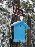
If you do not ski cross-country, you might ask,"How does one find their way through a forest of new-fallen snow that has obliterated all tracks AND the trail?" Every few yards is a trail marker in a tree; it is attached high off the ground to prevent being buried during a deep snowfall.
The Bechtel Shelter is a welcomed haven from unexpected storms for snow travelers, whether they be on skis or snowshoes.
Thanks to the hard work of volunteers, an ample supply of firewood is stacked during the summer. An axe is provided to split kindling to aid in starting a fire in the wood stove for heating and cooking. The rising, warm air provides toasty comfort while sleeping in the "upstairs" loft!
Cross Country Skiing
At the Gold Lake Sno-Park, one mile west of Willamette Pass, is a parking area to begin cross country skiing north or south. This is near the Pacific Crest Trail system in which one could ski, theoretically, from Canada to Mexico, IF there was enough snow!
Today, I'll be skiing to Bechtel Shelter. For skiers who are new to the area, there are signs at each junction of trails directing the uninitiated to their goal. There are many trails and several shelters along the crest of the Cascade Mountains. The blue board will soon have a "You are here!" map of the area mounted for the directionally dyslexic.
Winter, wearing a mantle of white, brings sublime beauty to the forests. As I ascend the mountain, I look back at my ski track. One of trails to the shelter follows this route, which is a logging road in the summer. On weekends, volunteer ski patrolmen ski these trails to aid anyone who might be in distress.
Once in awhile, I'm able to glimpse an alpine ski area through the trees. It is "The Pass," situated at 5,120 feet at the summit of Willamette Pass. We were on the ski patrol there in the early 1970s. At that time, the area had one poma lift and one rope tow on one slope. Now there is one high-speed "six-pack," three triple and one double chairlifts that range from the front to the backside of the peak. These service 29 downhill trails.
Bechtel Shelter is one of several shelters in this general area of Willamette Pass. Thanks to volunteers, it is stacked with fire wood before the snow flies and has a wood stove for heat. The sleeping area is "upstairs" where the warm air from the stove accumulates. All shelters can not be reserved and are on a first come, first served basis. However, back country skiers are quick to share the shelter with other adventurers.
On every ski outing, I always bring a thermos of hot chocolate. The thought of its warmth, sweetness and thirst-quenching flavor is a powerful incentive to kick and glide my way back to the car. The skis are hurriedly placed on the cartop ski rack, and I plunge into my guiltless chocolate addiction ... and wash down a granola bar!
Subscribe to:
Posts (Atom)